
9-Day Rwenzori Mountains Hiking Safari — Margherita Peak (5,109m)


Overview
The Rwenzori Mountains — known historically as the Mountains of the Moon — straddle the Uganda–DRC border on the western arm of the Albertine Rift. Margherita Peak at 5,109m is the highest point of Mount Stanley and the third highest mountain in Africa, after Kilimanjaro and Mount Kenya. Unlike either of those peaks, the Rwenzoris are not volcanic — they’re a block-faulted massif pushed upward along the Rift, permanently glaciated, and wrapped in some of the most botanically extraordinary vegetation on the continent.
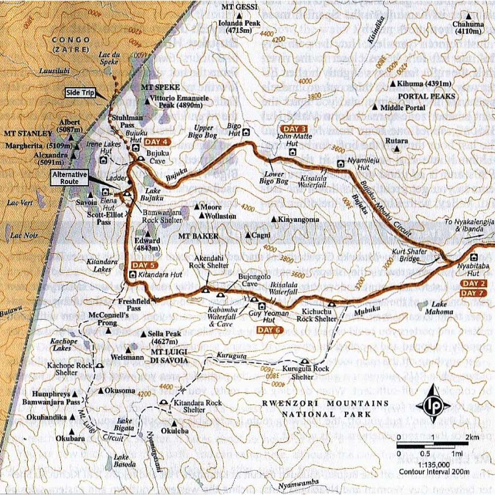
This 9-day itinerary follows the central circuit via Kasese and the Nyakalengija trailhead, climbing through five distinct ecological zones: lowland rainforest with colobus monkeys and Rwenzori turaco, bamboo and giant heather, the otherworldly lobelia and groundsel zone, the high alpine rocky terrain approaching Elena Hut, and finally the glacial approach to the Stanley Plateau and Margherita summit. The route is a loop — up via John Matte, Bujuku, and Elena, then down via Kitandara, Fresh Field Pass, Guy Yeoman, and back out through Nyabitaba.
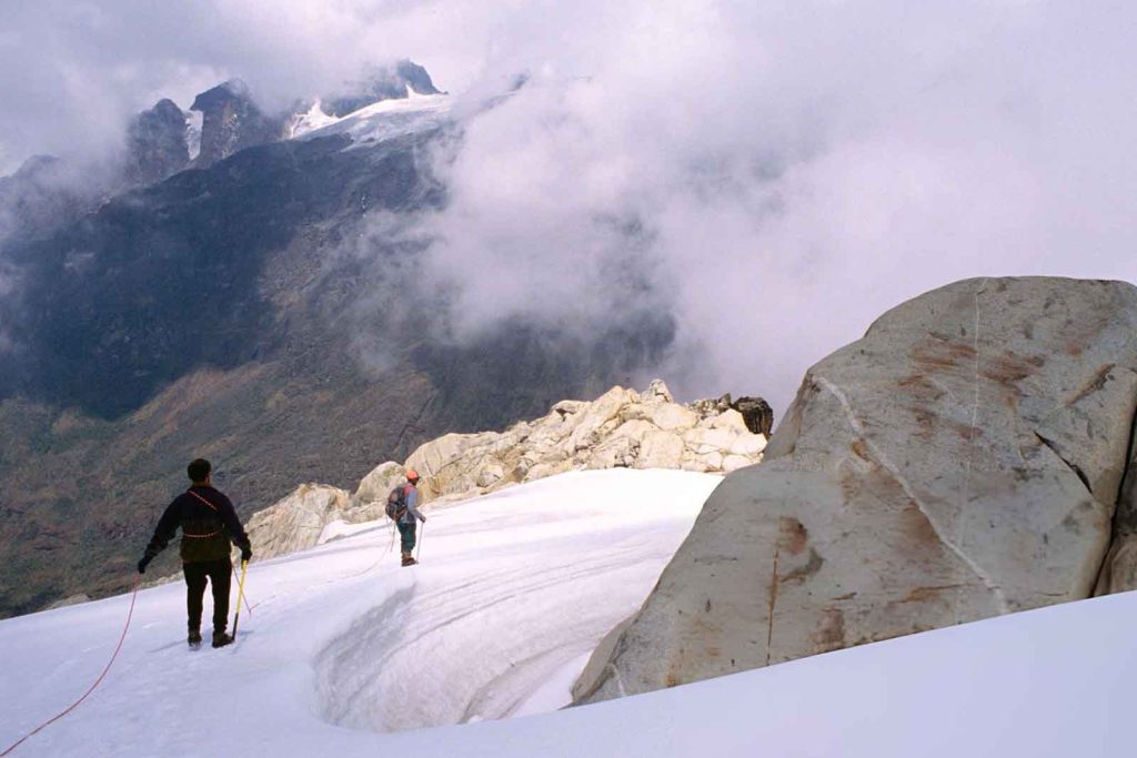
Six consecutive days are spent on the mountain, averaging six to eight hours of hiking per day, with nights in designated mountain huts. On summit day (Day 6), the pre-dawn start over glaciers and icy terrain to Margherita is the physical and emotional climax of the entire trek.
It suits experienced hikers with good cardiovascular fitness and prior multi-day trekking experience — not necessarily technical mountaineers, but people comfortable with altitude, sustained effort, and challenging terrain across consecutive days.
Key Information:
- Duration: 9 days (6 days on the mountain, 1 day travel each end)
- Departure Location: Entebbe International Airport
- Trip Type: Private, tailor-made / Physical

People expect it to be like Kilimanjaro — you walk up, you walk down. The Rwenzoris are completely different. The bogs, the giant lobelias, the mist, the glaciers above you. It's unlike anything else in Africa.
Highlights
- Summit of Margherita Peak (5,109m) — Africa’s third highest point, via pre-dawn glacier approach
- Giant lobelias, groundsels, and heathers found only in the Rwenzori Mountains
- Lake Bujuku with views of Mount Baker and Mount Stanley
- Fresh Field Pass (4,282m) with views over the Congo basin
- Bujongolo rock shelter — Duke of Abruzzi’s 1906 base camp
- Rwenzori turaco, three-horned chameleon, and colobus monkeys in the lower forest

General Information
The Rwenzori Mountains National Park is a UNESCO World Heritage Site covering 996 km² along the Uganda–DRC border, west of Kasese. The range contains six massifs — Stanley, Speke, Baker, Luigi di Savoia, Emin, and Gessi — of which Mount Stanley holds Margherita Peak, the highest point of the entire range and of Uganda. The mountains are permanently glaciated above around 4,500m, though the glaciers have retreated significantly over the past century.
What makes the Rwenzoris botanically unique is the equatorial altitude effect — the same alpine zones found on other mountains are exaggerated here into surreal, giant forms. Tree heathers grow to 10 metres, lobelias tower overhead, and groundsels reach the size of small trees. This bizarre, prehistoric-looking vegetation concentrated between roughly 3,000m and 4,500m is one of the most visually distinctive landscapes anywhere in Africa and accounts for a large part of the trek’s appeal beyond the summit itself.
The Bakonjo people have lived on the lower slopes of the Rwenzoris for generations — the trailhead at Nyakalengija passes through their homesteads and banana plantations, and the mountain guide and porter teams are drawn from the local community.

What's Included?
- Accommodation in mid-range lodges (Mihunga Lodge) and mountain huts throughout
- Meals as indicated in the itinerary
- 1 Rwenzori Mountains trekking permit and park entrance fees
- All excursions as listed under supervision of a professional English-speaking trekking guide
- Ground transport and transfers in a 4×4 safari Land Cruiser (Entebbe–Kasese–Entebbe)
- AMREF emergency evacuation insurance cover
- Government taxes
- International flights to/from Entebbe
- Travel insurance (required — not provided)
- Uganda tourist visa costs and processing
- Porter fees (porters available for hire — strongly recommended)
- Personal trekking equipment (boots, gaiters, sleeping bag, layers — full kit list provided on booking)
- Extra activities and meals not listed in the itinerary
- Service tips, gratuities, souvenirs, and snacks
- Accommodation after the end of the trip
Detailed
Itinerary
This 9-day itinerary allocates one day at each end for road transfers between Entebbe and Kasese, leaving six full days on the central circuit. The circuit is designed as a loop, with each day building in altitude to acclimatise progressively — Nyabitaba at 2,651m, John Matte at 3,505m, Bujuku at 3,962m, and Elena at 4,541m before the summit push on Day 6.
Daily hiking time averages six to eight hours. The terrain varies significantly across zones — the lower forest is well-maintained trail, the bamboo and heather zone involves slippery, moss-covered rock, the Bigo Bog requires careful tussock navigation, and the upper alpine terrain above Elena is increasingly rocky and icy. Summit day adds glacier travel and altitude demands on top of the physical effort.
The mountain huts provide basic shelter throughout — sleeping bags and warm layers are essential from Bujuku upward. Porters are available for hire and are strongly recommended; they carry loads, know the terrain, and are an important source of income for the local Bakonjo community.
Testimonials
What Our Travellers Say


Some of Our
Frequently Asked Questions
This is a physically demanding, multi-day mountain trek rated as challenging. You should be in good cardiovascular fitness and comfortable with six to eight hours of sustained hiking on consecutive days across uneven, often wet terrain. Prior multi-day trekking experience is strongly recommended. Technical mountaineering skills are not required — summit day uses fixed ropes and your guide handles the glacier equipment — but you must be comfortable with exposed, icy terrain at altitude. If you’ve done routes such as Kilimanjaro or alpine trekking in Europe, this is a comparable commitment.
Crampons and an ice axe may be required on summit day depending on conditions. Your trekking guide carries and fits this equipment — you do not need to bring your own. You will need a warm sleeping bag rated to at least -10°C, full waterproofs, gaiters, a headtorch, trekking poles, and layered warm clothing from Elena Hut upward. A full kit list is provided on booking.
The huts on the central circuit are basic but functional — bunk beds, blankets, and simple cooking facilities. They are not hotels. You need a sleeping bag and warm layers from Bujuku upward. The huts are managed by the Rwenzori Mountaineering Services (RMS) and are the only sleeping option on the circuit. Conditions are clean but austere.
Yes — strongly recommended. Porters carry loads of up to 20 kg, know the terrain intimately, and provide significant logistical and safety support on the mountain. Porter fees are not included in the trip price and are paid directly; your guide will advise on the appropriate number for your group size. Hiring porters directly supports the local Bakonjo community whose land borders the park.
The Rwenzoris receive rainfall year-round — it is genuinely one of the wettest mountain ranges in Africa. The drier windows are roughly December to February and June to August, when conditions on the upper mountain are somewhat more stable and summit success rates are higher. That said, cloud and rain at some point during any trek is near-certain regardless of timing. Come prepared for wet conditions at all elevations.
Yes. The Rwenzoris are located close to Queen Elizabeth National Park, making a two to three night QENP extension natural before or after the trek. Bwindi gorilla trekking can be added at the southwest end. Some travellers also combine the Rwenzoris with the lower Rwenzori slopes day hike itinerary as an acclimatisation option — ask the team about shorter trekking alternatives if the 9-day summit route is beyond your current fitness level.
